By David McCall, Ph.D.
Let’s face it: stress levels are high for everyone these days, and the thought of embracing a new technology with a steep learning curve isn’t at the top of many people’s to-do list. Budgets have become incredibly tight with limited resources or labor, and things are only going to get worse as more and more fields open up back up. Our personal stress levels are high, but so is the stress level of many of the playing surfaces with increased play (either currently or imminent, depending on your locale). Most sports field managers want to manage pests at their facility as efficiently as they can and then move on to the next task to hurdle. The last thing that most turfgrass professionals want or need in their lives is someone telling them that they need to change from something that works well into some new, unknown technology with more questions than answers. But guess what? I’m going to do it anyway, or at least introduce some of the concepts that will hopefully start a slow, steady shift toward getting the right product or practice to the right place, at the right time. This approach is the crux of precision turfgrass management.
We have all heard the saying, “You’re only as strong as your weakest link.” That saying is true, and that is the way that we almost always manage our fields. If an area along the third base line looks dry, we run an irrigation cycle for the entire field. If the soccer goalmouth is showing signs of compaction, we deep tine the field as soon as we can catch a break in the action. If part of the playing surface shaded by the east stands is attacked by the gray leaf spot pathogen, we treat the field with a fungicide. All because of that weakest link. In reality, there are ways to address that weak link without replacing the entire chain. It just takes some thought and monitoring.
Turfgrass surfaces are not uniform. No matter how much effort we put into it, how much initial planning and preparation at establishment, or how evenly distributed the sand cap is across a well-designed internal drainage system, we’re still not going to have a perfectly uniform playing surface. Period. After all, we are dealing with massive number of biological organisms. So why do we treat the entire fields the same when we know that some areas are clearly struggling more than other areas? Because it is the safer route (CYA!), and one that we’re more comfortable with. It is also perceived to be the easier route because of mixing up the tank, turning on the spray booms, and driving. I get it. I see the reason for treating everything the same. But pesticides cost money. Fertilizer costs money. Solid-tining a field takes time and money. Plus, even the safest chemicals (most new active ingredients fall in this category) can still have some negative environmental consequences, and the public is always watching. Now, let’s circle back around to the pesky concept of precision turfgrass management so we can start thinking about saving money and enhancing our environmental profile.
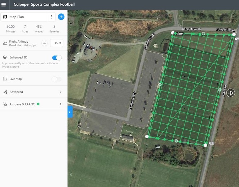
On the surface, precision turfgrass management sounds easy; and sometimes it can be. We find out where the problems are occurring, and we address the problem only in that area. But it can also get much more complicated in a hurry, and that is when many people begin to tune out the noise. It can be like traveling to a different country where another language is spoken, and that takes us out of our comfort zone. If you’ve never heard of waypoint navigation, orthomosaicking, or georectification, you’re not alone. These were all new concepts to my group not too long ago, but we have started to incorporate these things into our language. And now we are able to understand how a pest incidence map can point us to where problems need to be addressed. But let’s start simple.
Pest incidence maps can be built in a variety of ways with varying levels of technology. I started decades ago, without even knowing it, when I would draw scouting maps to know where to place fungicide efficacy trials. These were hand-drawn maps with a few geographical features added in for a frame of reference. To do my due diligence for this article, I checked online and found that paper can be purchased for around two pennies, and pens are available for a shade under a dime. That is a pretty cheap start to precision turfgrass management. Now take the next baby step toward understanding a pest outbreak by making your hand drawing on an aerial printout of your facility from Google or Bing Maps (the cost just went up to now cover the cost of printer ink). Looking at a facility from above truly helps understand how a pest is distributed across large surfaces, particularly when we also have the general knowledge of underlying conditions that may not be seen in a snapshot in time, such as poorly drained or shaded areas. It is surprising how much more detail can be gleaned about a pest outbreak just by adding the context of an actual image with our personal on-site experiences as an agronomist.

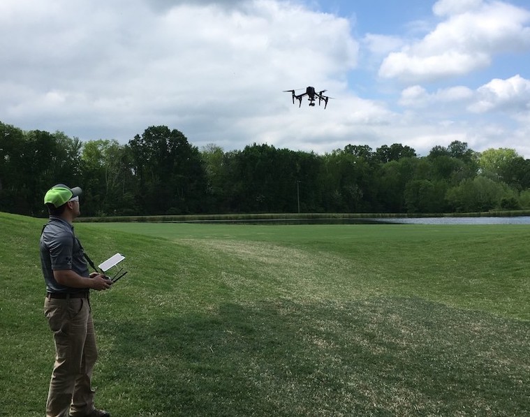
One thing that Google Maps can’t provide – unless you are incredibly lucky – is the element of time. Most pest outbreaks are triggered by the environment and can’t be scheduled ahead of time, which makes the timing of image capture so critical. Drones have dramatically changed the way we think about taking a quick, bird’s-eye-view look at our facilities. There are many cheap options available that will allow for a quick peak almost anytime it seems appropriate that just aren’t possible when relying on another aerial mapping service. However, this is just one single picture and you may miss some important details that aren’t possible to capture with sufficient image quality. Adding waypoint navigation to slightly upgraded drones allows us to set an area of interest and collect hundreds of images automatically. Those hundreds of images can be stitched together like a puzzle to create one large, cohesive image. This is where things really start to get fun, once we get past the stigma of not being a formally trained computer scientist.
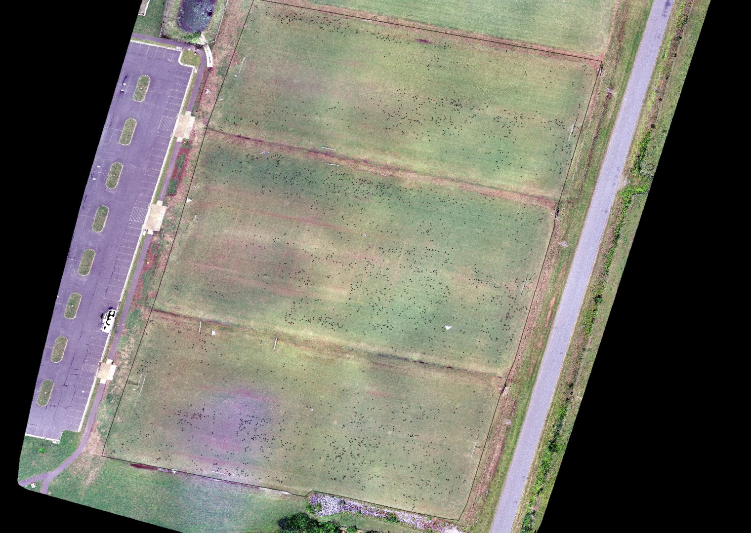
Once the skills of hand-drawn pest maps are mastered, it is time to begin discussing automated digital image analysis, unsupervised image classification, machine learning and other forms of artificial intelligence on georeferenced images. All it takes is some advanced computing algorithms and writing computer code… nah, I can’t do that either! But I can speak the language, which wasn’t always the case. Our lab (along with others around the country) has spent considerable time over the last few years improving the automated process of developing maps for precision turfgrass management. Several equipment manufacturers have developed GPS sprayer capabilities with individual nozzle control that have great potential for chemical savings while making targeted pesticide applications. In a note of success, our lab was able to suppress spring dead spot of bermudagrass using disease incidence maps for targeted fungicide applications. The results: comparable control to blanket applications and a fungicide savings of 51 to 65 percent. Not bad for a maiden voyage.
We are collaborating with a group of scientists throughout the country to develop additional uses and to further fine-tune successful options for precision turfgrass management. The technology is there, but the current process is far from perfect at this time. There are overestimations and underestimations of where a computer “thinks” there are pests. The integration from one system to another isn’t flawless yet. A few choice words have been said in the heat of battle with the equipment, but we typically still come out as friends at the end of the day. And in keeping with the bottom dollar, the waypoint navigation, stitching and GIS software are all open-access and/or free. Our goal is to provide open-source computer codes that can become plug-and-play as mapping and GPS sprayer technologies continue to evolve. Costs can be quite low and the recipes will be written. Budgets are tight these days, so isn’t this the type of strategy worth investigating a little more on your end?
Think about this. The time you have spent reading this article could have been spent building your first pest incidence map and set you on a path toward effective precision turfgrass management. What are you waiting for? Get to it!
David McCall, Ph.D., is an assistant professor and extension turfgrass pathologist at Virginia Tech, in the School of Plant and Environmental Sciences. His current research focuses on early stress detection using drones and field radiometry, site-specific management using GPS-guided sprayers, and other novel strategies to reduce pesticide inputs. Extension responsibilities include developing and sharing practical solutions to suppress diseases of turfgrasses grown for sod, commercial and residential lawns, and recreational facilities, such as golf courses and athletic fields.
Funding for this research has been provided by the Virginia Agricultural Council, Virginia Turfgrass Foundation, Golf Course Superintendents Association of America (including Virginia Chapter), PBI Gordon, The Toro Company, and Syngenta Professional Products. Additional collaborators include TurfScout LLC, The Drone Co. RVA, and the Virginia Tech Unmanned Systems Laboratory.