By Jody Gill, CSFM
I remember my first airplane. It was a PT-19 with a Cox 049 gas engine tethered by a control cable. It required you to spin around in a circle while controlling it with the tether. It would fly for about 3 minutes, run out of fuel, and crash land but it was the greatest thing ever invented! I have always wondered if all that spinning around as a 10-year-old caused my attention-deficit disorder.
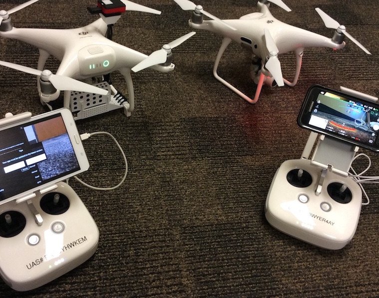
We’ve come a long way since those days. Modern drones practically fly themselves with GPS guidance and accuracy. The most common use of drones is for simple aerial photography. Recently, they have become valuable agronomic and engineering tools to accomplish tasks including 2D mapping and 3D modeling, rooftop heat loss measurement with FLIR cameras, and monitoring crop and turf health using NDVI cameras. My drone program uses a DJI Phantom 4 (P4) equipped with a Parrot Sequoia NDVI multispectral sensor and a DJI Phantom 4 Professional (P4P) for general aerial photography and Pix4D data collection.
I chose these units because they have outstanding obstacle avoidance sensors, high quality cameras, are relatively inexpensive, and easy to fly. The P4P has a 20 MP camera with a 1-inch sensor and a global shutter making it an outstanding tool for photography. The P4 has a slightly lower quality camera with a linear rolling shutter that is less-than-ideal for aerial photography while moving on a grid. However, it was the perfect flying platform for the NDVI camera over relatively small properties; when used for aerial mapping, these drones are simply flying a programmed grid above a property while taking hundreds of high resolution, geo-located photos with special cameras. The overlapped photos are then processed by Pix4D software to generate millions of geo-referenced GPS points to create 3D point clouds.
This data can then be used to perform volume calculations, create contour lines with elevations, create digital surface and terrain models, evaluate crop health and much more. This is just one of the ways we use drones to gather data for facilities and property management.
Selling it
So how can you sell this idea to your administration? As with any new idea, it is important to know your subject matter and show your dedication and passion for the idea. Whether you want to simply get aerial photos of your fields or measure heat loss through the roof of the gym, you must establish a need, determine costs, calculate the return on the investment, and define how the drone will be used safely.
The need could be as simple as having the aerial perspective to better manage your fields, so let’s start there. It is true that you can see much more from the air than you can from the ground. Football coaches and band directors always do a great job of convincing administration that they can be more effective if they can have a view of the practice or the game from a much higher elevation, such as having an aerial platform or a telescoping end zone camera. Sports turf managers are no different. Just having that aerial perspective of a large sports field can give you early indications of a developing problem such as excessive wear on a specific area.
The cost for a good quality drone ranges from $1,500 for a quadcopter to $20,000 for fixed wing aircraft. It is important to know how you want to use the drone before estimating purchase costs. For example, a large agricultural operation would likely need fixed wing aircraft for mapping since they are lighter, faster and have a much longer battery life to be able to cover large tracts of land. A real estate firm photographing small properties would be better served with a smaller and cheaper quadcopter with a shorter battery life but allowing faster deployment and retrieval.
Importance of pilots
The most important part of a drone program is safety and pilot competence; yes, I said pilot. Although drones are very easy to fly with GPS assistance, the pilot must be prepared and skilled to be able to control the drone and bring it back if it flies away due to loss of control link or GPS signal. Whether you are flying a manned aircraft or controlling a drone from the ground, you are piloting an aircraft in an environment where many things can go wrong and result in a serious accident. If you are flying a 4-pound drone at 400 feet and it loses power, it will hit the ground in about 6 seconds at a speed of more than 100 mph with an impact force of about 1,500 foot pounds. If this happens, someone will likely be held accountable and liable for damage or injury.
Whether you are flying your personal drone or an employer-owned drone, you should have liability insurance coverage. The drone insurance market is changing daily. Generally, public entities will need to add a rider to their general liability policies, which can cost from several hundred to several thousand dollars per year. With proper pilot training, regular drone safety inspections and a solid flight safety program, the chances of a serious accident are slim. However, having appropriate and adequate liability insurance is a must.
Additionally, the Federal Aviation Administration (FAA) requires that commercial use drones weighing between .55 and 55 pounds are registered through a simple and inexpensive online process. There are severe civil and criminal penalties if you are caught flying an unregistered commercial drone. I am not trying to scare you away from drone operations but instead encouraging you to take safety, liability and regulations very seriously.
Another important factor is knowing where you can legally fly. Most large schools or parks will likely be within class B, C or D controlled airspace. The FAA provides a helpful and free app called B4UFLY. This app will use your smartphone location to tell you whether or not it is safe and legal to fly. In order to fly within controlled airspace, you must seek permission from the airspace authority. You must either obtain a certificate of authorization (COA) from the FAA or negotiate an agreement with your local airport authority and establish a letter of understanding. Obtaining a COA can be a difficult and lengthy process sometimes taking several months for a response but if you plan to fly in various locations across the country it is the best option. There are several FAA online publications that will provide details on how to submit an application for a COA. If you plan to fly within the same controlled airspace regularly, it may be easier to work directly with your airport authority and establish procedures for obtaining daily flight authorization.
There is much debate regarding the need for a part 107, remote pilot certificate. According to the FAA, if you are flying as a hobby or just for fun and you are not being paid or trading services in return for some version of drone service, certification is not required. If you are flying your personal drone in your backyard during just for fun, there is no question this would be recreational flight. What about flying your personal drone at work, during regular working hours for the purpose of getting aerial photos that will make it easier for you to show your crew a specific need on the property? This could easily be considered commercial flight since you’re being paid to fly for the benefit of another entity.
What if the drone is employer-owned? How would this change the equation? For anyone who has an interest in flight, the certification is achievable. The part 107, remote pilot exam will test your knowledge of airport operations and communications, basic flight physics, understanding aeronautical charts, flight weather, emergency procedures, etc. There are a number of inexpensive apps available for Part 107 exam preparation if you prefer learning on your own. I used the $30 FlightReady Academy app and felt well prepared to pass the challenging FAA exam. There are also multi-day training schools where you can learn to fly a variety of drones while preparing for the exam. Having the FAA certification will make it easier to get your drone program approved, obtain insurance and receive permission for flight within controlled airspace.
In October 2017, President Trump announced a new initiative to bring together Unmanned Aircraft System (UAS) pilots with state and local governments to work towards expanding UAS operations. The UAS Integration Pilot Program is intended to “shape a regulatory framework that balances the benefits of UAS technology while lessening the risks to public safety and security.” Drone technology will continue to impact agriculture and sports turf management in ways we can’t imagine yet. It is very important that we use this valuable tool carefully and responsibly to insure that it remains readily available for use in our industry.
Jody Gill, CSFM, Secretary/Treasurer of the Sports Turf Managers Association’s Board of Directors, is an FAA-certified UAS pilot and grounds coordinator for the Blue Valley School District, Overland Park, KS.