New technology can bring a unique perspective to turf management. Unmanned aerial vehicles, or “drones,” can provide valuable information to aid sports turf managers. As part of a management program, drones can save time, labor, and money.
Drones are semi-autonomous aircraft that come in a variety of shapes and sizes (see photo). Drones are capable of fully automated flight via GPS-based navigation or manual flight via radio-controlled transmission. They are available as multi-rotor helicopters and fixed-wing aircraft. Companies including Quadcopter, LLC, Lehmann Aviation, Pixobot, LLC, MicroPilot, Inc., and senseFly, Ltd. manufacture and sell drones for public use or provide drone-related services. They can be relatively small, about the size of a large pizza, to several feet in diameter or length. Drones require little technical training and do not require a pilot license for operation. They can operate in a wide range of environmental conditions. Drones can fly in hot or cold temperatures, humid or dry air, and sunny or cloudy skies. Although Federal Aviation Administration regulations currently prohibit drone flights for commercial operations, rule changes could come as early as 2015. Recently, farmers were granted permission to operate drones over their own property for personal use, in accordance with guidelines established by the Academy of Model Aeronautics.
What drones do
In a turf management program, drones are best used as a platform for collecting aerial imagery. Digital cameras collect visible light reflected from surfaces. Visible light is the portion of the electromagnetic spectrum “visible” to the human eye; it ranges from 400-700 nanometers (nm) in wavelength. Digital cameras record visible light information into three channels—red, blue, and green (RGB)—that make up each pixel in an image. Imagery can provide real-time information on many aspects of turf quality important to turf managers.
Images can be analyzed with computer software and used to quantify turf status through a process called digital image analysis (DIA). The DIA method is recognized for its ability to objectively quantify many turf quality parameters, including percent green cover, turf color (via a dark green color index, or DGCI), fertility, chlorophyll index (i.e., “greenness”), and others. The objective nature eliminates variability associated with subjective visual ratings.
In addition to their impact on visible light reflectance, many turf stresses largely impact reflectance in the near-infrared (NIR) region of the electromagnetic spectrum. Near-infrared is the portion of radiation just beyond that visible to the human eye, ranging from 700-1300 nm in wavelength. The NIR provides the ability to “see” stressed areas otherwise invisible. Near-infrared radiation can be detected and recorded using a modified digital camera. Modification costs are relatively inexpensive, costing about the same price of a new mid-grade digital camera; pre-modified digital cameras are also commercially available.
Research at the University of Nebraska-Lincoln John Seaton Anderson (JSA) Research Facility near Mead, NE, in 2010-12 has shown RGB and NIR information in digital images can be extracted with computer software and used to quantify turf quality and stress. Two commonly used agronomic measurements include chlorophyll index (CI) and the normalized difference vegetation index (NDVI). Although computed somewhat differently, each is an objective measurement of turf “greenness,” calculated by mathematical manipulations of red and NIR reflectance data. Other methods based on analogous principles involve handheld sensors. Handheld sensors are commercially available that measure visible and NIR reflectance from turf and quantify a value. Researchers have demonstrated high correlations among multiple turfgrass quality parameters with handheld CI and NDVI, making them robust, objective measurement tools. However, no attempts have been made to correlate these sensor data with a DIA system that incorporates NIR reflectance.
A dual-camera (regular + NIR) DIA system may be a convenient, reliable, low-cost alternative to handheld sensors for collecting turf quality data. Regular and NIR-modified digital cameras used in tandem can record RGB and NIR reflectance data for each image. These data could provide CI and NDVI information, as well as percent cover, DGCI, and traditional DIA measurements.
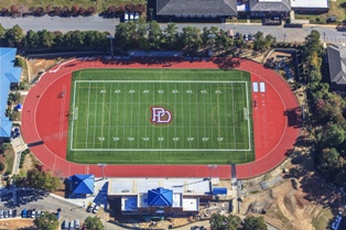
Furthermore, by combining DIA with drone technology, efficiency of collecting turf information increases dramatically. Drones provide the ability to image large areas, common in sports turf, in short time spans. For example, entire football fields can be imaged in minutes. By comparison, collecting imagery of equivalent area by hand would take several hours. Turf affected by various stresses, including water, fertility, disease, and insect damage, could easily be detected. In addition, because drones can collect information on entire areas in one image, effects of changing sunlight and cloud conditions are eliminated, increasing accuracy.
Research conducted at UNL in 2012 investigated effectiveness of a drone-based, dual-camera (regular + NIR) DIA system for measuring CI and NDVI compared to handheld sensors. An ongoing deficit irrigation field study established in 2009 was used. Deficit irrigation was applied via a linear gradient irrigation system, such that turf closest to the sprinkler line source received 80% evapotranspiration (well-watered) and turf farthest received no irrigation (rain-fed); plots were divided into eight equal sub-plots that differed in irrigation and replicated four times. This design provided a broad range of turf qualities for analysis. Plots were mowed twice weekly at 2.5 inches, fertilized at 3 lbs N∙1000 ft-2∙y-1, and received regular pre- and postemergence herbicide applications.
Aerial imagery was collected using a custom-built, GPS-controlled hexacopter equipped with a digital camera (Pixobot, LLC, Lincoln, NE). Aerial imagery of Bowie buffalograss (Buchloe dactyloides), 4-Season Kentucky bluegrass (Poa pratensis), Apple GL perennial ryegrass (Lolium perenne), and Spyder tall fescue (Festuca arundinacea) was collected on 6 days approximately every 4 weeks from early April through late September. Imagery was collected in full sun between 1200 and 1400 hr. The NIR imagery was collected immediately following regular image capture. A CI and NDVI were calculated for each image using the RGB and NIR data. The CI was calculated as (NIR / Red) – 1 and NDVI calculated as (NIR – Red)/(NIR + Red), based on equations developed by previous researchers. Traditional DGCI (which does not use NIR) values were also calculated for comparison against CI and NDVI.
Chlorophyll index and NDVI data were also collected using handheld sensors. The CI and NDVI were measured using a Spectrum Technologies FieldScout CM 1000 chlorophyll meter and FieldScout TCM 500 NDVI turf color meter, respectively. Scores were averages of three random measurements taken in the center of each plot. Handheld sensor data were collected the same days as aerial imagery.
Our results showed strong correlations between drone-based CI and NDVI and handheld sensor data. On average, drone-based CI data were highly correlated (R » 0.84) with handheld CI values across turfgrasses. Similarly, drone-based NDVI values were highly correlated (R » 0.79) with handheld NDVI values across turfgrasses. The drone-CI and -NDVI values were better correlated with handheld sensors than DGCI in all but one case.
These results suggest drone-based imaging using regular and NIR-modified digital cameras can provide information equivalent to handheld sensors. This allows CI and NDVI data to be collected in a fraction of the time required for handheld collection. Though our study used water-stressed turf, many other stresses and cultural practices have been correlated with handheld CI and NDVI, suggesting other stresses can be equally detected with drone-based DIA. These results also show addition of an NIR component to DIA increases ability to measure “greenness,” illustrated by the stronger correlations with handheld CI and NDVI sensors than DGCI, which does not use NIR data.
Monitoring changes over time
Drones can provide additional information valuable to sports turf managers. By using drones, changes in turf can easily be monitored over time. Furthermore, using drones to create GPS-based maps can easily pinpoint areas of turf stress. This information can then be used by sports turf managers to address the problem, whether it is increasing an irrigation zone run time to alleviate localized drought stress or increasing nitrogen fertility to correct chlorotic turf. With DIA, it is possible to model and calculate corrective measures (i.e., nitrogen rate must be increased by 0.20 lbs N∙1000 ft-2 to alleviate turf chlorosis) with little error and simple mathematics, minimizing waste.
Future implications of drones in sports turf management are ongoing. Drones could be programmed to take off, fly routine routes, and land at specified time intervals, providing automated turf data over time. Drones could automatically detect turf problem areas with onboard software and generate GPS-based maps on the fly. If networked wirelessly to irrigation controllers, drones could trigger site-specific irrigation events to correct for localized dry spots detected during flight in real time. Drones also can be used to gather information other than imagery. Thermal-infrared imaging or infrared thermometers can measure turf canopy temperatures, which can indicate water stress. At UNL, preliminary work has begun on engineering drones for weed-control technology. The goal is to program drones to automatically seek, detect, and spray weeds with onboard herbicides.
By providing a birds-eye view of turf, drones can quickly and efficiency gather useful information regarding turf status that can aid in management. Through DIA, drones can provide quantitative information about turf in a timely and efficient manner. Turf parameters such as “greenness” (via CI and NDVI), color, percent green cover, and various stresses can be detected quickly and easily. The information from drones can lead to better-informed decisions. Thus, drones offer many advantages to sports turf managers that ultimately save time, reduce labor, and lower costs.
Scott M. Dworak is a PhD candidate, University of Nebraska-Lincoln Adjunct faculty, Biology Department, Doane College; Dr. Roch E. Gaussoin is head of the Department of Agronomy & Horticulture and Professor of Turfgrass Science, University of Nebraska-Lincoln; and Vishal Singh is with Pixobot, LLC.